
Local Tibet Tours
Quick Enquiry
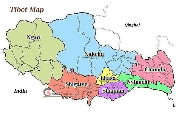
Tibet Regional Guide
With an average elevation of 4,900 meters (16,000 ft), it is the highest region on Earth and is commonly referred to as the "Roof of the World." Tibet embraces the holy city Lhasa, Shigatse (Xigaze), Ngari Region, Chamdo (Qamdo) Region, Nyingchi Region, Shannan (Lhoka, Lhokha) Region, Nakchu (Nagqu) Region and other 73 counties.
![]() ChinaTourGuide.com takes you to discover the mysterious facts about Tibet, and brings you the most real traveling experience in Tibet. For more detailed Info, please visit our the most fresh Blog:
ChinaTourGuide.com takes you to discover the mysterious facts about Tibet, and brings you the most real traveling experience in Tibet. For more detailed Info, please visit our the most fresh Blog:
Six Day Journey to My Dreamland - Tibet!
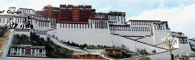
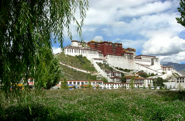
![]() Lhasa
Lhasa
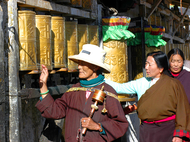
Lhasa is the capital city of Tibet Autonomous Region (TAR) and has long been the center of politics, economy, culture and religion in Tibet. Lhasa means "holy land" in Tibetan language. The history of city dates back to the 7th century AD, when the Tibetan King Songtsen Gampo conquered many tribes, united Tibet, transferred the capital from Yarlung to Lhasa, and established Tubo Regime. With Potala Palace as its center, Barkhor Street and Norbulingkha Palace on both sides, Lhasa is one of the most charming cities in Tibet. The grand Potala, the blue sky, the clear water and the fresh air all add charm to the city. The total population of the city is around 373,000 and the total population in the urban area only is close to 130,000. People of 31 nationalities live in the city and Tibetans take up 87% of the total population. Lhasa is located in the valley of Lhasa River, a branch of Yarlung Tsangpo River. It is 3,658 high in altitude. The city has jurisdiction over 7 counties and one district with an area of 300,000 square kilometers. The total area of urban section is 523 square kilometers.
![]() Shigatse (Xigaze)
Shigatse (Xigaze)
Located in the alluvial plain at the confluence of Brahmaputra and Nianchuhe rivers, Shigatse is 273 kilometers west to Lhasa. At an elevation of 3,800 meters, with the area of 3,875 square kilometers and population of 820,000, it is the second biggest and the only county-level city in Tibet. Also, it is an ancient city in the altiplano with a history of nearly 600 years. It is named Xikasangzhuzi in Tibetan, and Xikazi for short, which stands for "a manor of the most fertile soil", and it is transliterated into Chinese as 'shigatse'.
Shigatse is a small city and big village as well, with the reputation of 'granary' of Tibet. The famous scenery spots include Tashilumpo Monastery, Palkor Monastery in Gyantse, Sakya Monastery, Pingcuolin Monastery, Juenang Monastery, Pala Manor and etc. Nowadays, Shigatse has become an important tourist attraction and transit of Tibetan golden tourist route, attracting countless tourists at home and abroad with its mysterious Tibetan Buddhism culture.
![]() Nyingchi Region
Nyingchi Region
Lying in the lower reaches of the Yaluzhangbu River southeast of Tibet, the Nyingchi Prefecture has the average latitude of approximately 3,000 meters above the sea level while the lowest place here is only about 900 meters above the sea level. This area is known for its mild wet weather and gorgeous landscape. The major townships and scenic zones include the Economic Area of the Niyang River Valley, Bayi Town and the Scenic Zones of Yaluzhangbu River. Among the above, the capital township - Bayi on the bank of the Biyang River, is the political and economic center of this prefecture.
![]() Chamdo (Qamdo) Region
Chamdo (Qamdo) Region
Located in eastern Tibet, Chamdo prefecture is contiguous with Sichuan Province to the east, Yunnan Province to the south and Qinghai Province to the north. Chamdo has a total population of 583,600, which accounts for 12% of the total population of Tibet Autonomous Region. Around Chamdo, there are the splendid sceneries of "Sacred Mountain and Holy Lake" of the Buddhism, Hinduism and the indigenous religion-Bon. There are also sites and ancient monasteries, buildings, steles, such as the Chambaling Monastery, Kanuo Ruins in Chamdo. The rich folk customs, religious culture and local festivals are still alive today.
![]() Ngari Region
Ngari Region
Located in the western Tibet Autonomous Region, Ngari Prefecture borders India, Nepal and Indian Kashmir and is contiguous with Xinjiang Uygur Autonomous Region, China, to the north and Shigatse, Tibet to the south. Ngari has a total area of 310,000 sq. kilometers, accounting for one forth of Tibet. Ngari is known as the "roof of the roof of the world and the most "Tibetan" part of Tibet. Ngari averages 4,500 meters. It's the place where the Himalayas, the Gangdise, the Kunlun Mountains and Karakorum Mountains meet. Mt. Kailash and Lake Manasarova in Ngari are symbolized as the "Sacred Mountain and Holy Lake" of the Buddhism and are the spiritual center of Buddhists.
![]() Shannan (Lhoka, Lhokha) Region
Shannan (Lhoka, Lhokha) Region
Shannan (Lhoka, Lhokha) Prefecture is known as the birthplace of the Tibetan people. It lies to the south of Mt. Kailash and the Nyainqentanglha Mountains, along the middle and lower reaches of the Yarlung Tsangpo River, and enjoys a comparatively mild climate. The prefecture covers an area of around 80,000 km2, with an average altitude of about 3600m and a total population of 290,000, including Tibetan, Han, Hui, Monba and Lhoba people.
At an altitude of 3551m Tsetang is 200 km from Lhasa. The only civil airport in this area, Gonggar Airport, is located midway between Lhasa and Tsetang. In this region, ranges, lakes, springs and river valleys constitute the featured landscapes. Yarlong Scenic Spot is the only national scenic spot in Tibet.
![]() Nakchu (Nagqu) Region
Nakchu (Nagqu) Region
Nakchu (Nagqu) is one of the important political, economic, cultural and trading centers as well as a transport hub in Tibet. It is also the collection and reshipment centre for the region's animal products, mineral ores, and agricultural and forestry products. Nagqu has a unique landscape. The ancient Yamtung (or Zhangzhung) cultural site, the Bon monasteries, the Holy Lake Nam-tso( or Lake Nam co) and the life of the highland herdsmen are unique tourist attractions.
![]() Altitude of Different Regions of Tibet
Altitude of Different Regions of Tibet
| Place | Altitude | Place | Altitude |
| Lhasa | 3658 m 12001 ft |
Nyingchi | 3000 m 9843 ft |
| Shigatse | 3836 m 12585 ft |
Tsedang | 3500 m 11483 ft |
| Nagqu | 4507 m 14787 ft |
Gyangtse | 4040 m 13255 ft |
| Pome | 2750 m 9022 ft |
Tingri | 4300 m 14108 ft |
| Amdo | 4800 m 15748 ft |
Zayui | 2325 m 7628 ft |
| Chamdo | 3205 m 10515 ft |
Damshung | 4200 m 13780 ft |

Guide for China tour, offers most value & amazing experience. In China, you can rely on us
Copyright © 2001 - 2025. All Rights Reserved to ChinaTourGuide.Com
Hotel Guangzhou | Guizhou Tours | Hong Kong Hotels | 香港酒店 | 广州酒店 | 广州会议酒店 | Indochina Tour
Guide for China tours, offers most value & amazing experience. Chinatourguide.com. Your reliable China tour agency.